From Wikipedia, the free encyclopedia
Original file (1,280 × 960 pixels, file size: 1.16 MB, MIME type: image/jpeg )
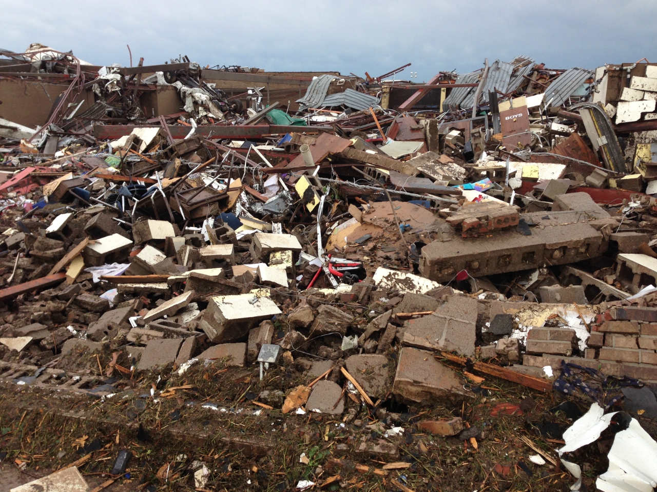
Summary
Date of Damage 05/20/2013 15:48 UTC
Date of Survey 05/21/2013 19:31 UTC
EF Rating EF5
Damage Indicator Elementary School [Single Story; Interior or Exterior Hallways] (ES)
Degree of Damage Total destruction of a large section of building or entire building
Latitude 35.32133326
Longitude -97.52087024
This File:NWS_2013_Moore_EF5_damage.jpg photo is explicitly identified as an example of EF5 damage in the NWS's kml file http://www.srh.noaa.gov/images/oun/wxevents/20130520/20130520-storm_survey_path_points.kmz as linked from http://www.srh.noaa.gov/oun/?n=events-20130520 as retrieved on 2013-06-17.
Licensing
Public domain Public domain false false
English What is left of Briarwood Elementary School in Moore, Oklahoma from the devastating EF5 tornado that tore through the city on May 20, 2013.
copyright status<\/a>"}},"text\/plain":{"en":{"":"copyright status"}}},"{\"value\":{\"entity-type\":\"item\",\"numeric-id\":19652,\"id\":\"Q19652\"},\"type\":\"wikibase-entityid\"}":{"text\/html":{"en":{"P6216":"
public domain<\/a>"}},"text\/plain":{"en":{"P6216":"public domain"}}},"{\"value\":{\"entity-type\":\"property\",\"numeric-id\":1001,\"id\":\"P1001\"},\"type\":\"wikibase-entityid\"}":{"text\/html":{"en":{"":" applies to jurisdiction<\/a>"}},"text\/plain":{"en":{"":"applies to jurisdiction"}}},"{\"value\":{\"entity-type\":\"item\",\"numeric-id\":30,\"id\":\"Q30\"},\"type\":\"wikibase-entityid\"}":{"text\/html":{"en":{"P1001":" United States of America<\/a>"}},"text\/plain":{"en":{"P1001":"United States of America"}}},"{\"value\":{\"entity-type\":\"property\",\"numeric-id\":459,\"id\":\"P459\"},\"type\":\"wikibase-entityid\"}":{"text\/html":{"en":{"":" determination method or standard<\/a>"}},"text\/plain":{"en":{"":"determination method or standard"}}},"{\"value\":{\"entity-type\":\"item\",\"numeric-id\":60671452,\"id\":\"Q60671452\"},\"type\":\"wikibase-entityid\"}":{"text\/html":{"en":{"P459":" work of the federal government of the United States<\/a>"}},"text\/plain":{"en":{"P459":"work of the federal government of the United States"}}}}" class="wbmi-entityview-statementsGroup wbmi-entityview-statementsGroup-P6216 oo-ui-layout oo-ui-panelLayout oo-ui-panelLayout-framed"> inception<\/a>"}},"text\/plain":{"en":{"":"inception"}}},"{\"value\":{\"time\":\"+2013-05-21T00:00:00Z\",\"timezone\":0,\"before\":0,\"after\":0,\"precision\":11,\"calendarmodel\":\"http:\\\/\\\/www.wikidata.org\\\/entity\\\/Q1985727\"},\"type\":\"time\"}":{"text\/html":{"en":{"P571":"21 May 2013"}},"text\/plain":{"en":{"P571":"21 May 2013"}}}}" class="wbmi-entityview-statementsGroup wbmi-entityview-statementsGroup-P571 oo-ui-layout oo-ui-panelLayout oo-ui-panelLayout-framed">
coordinates of the point of view<\/a>"}},"text\/plain":{"en":{"":"coordinates of the point of view"}}},"{\"value\":{\"latitude\":35.32133326,\"longitude\":-97.52087024,\"altitude\":null,\"precision\":1.0e-8,\"globe\":\"http:\\\/\\\/www.wikidata.org\\\/entity\\\/Q2\"},\"type\":\"globecoordinate\"}":{"text\/html":{"en":{"P1259":"35\u00b019'16.79974"N, 97\u00b031'15.13286"W"}},"text\/plain":{"en":{"P1259":"35\u00b019'16.79974\"N, 97\u00b031'15.13286\"W"}}}}" class="wbmi-entityview-statementsGroup wbmi-entityview-statementsGroup-P1259 oo-ui-layout oo-ui-panelLayout oo-ui-panelLayout-framed">
data size<\/a>"}},"text\/plain":{"en":{"":"data size"}}},"{\"value\":{\"amount\":\"+1219409\",\"unit\":\"http:\\\/\\\/www.wikidata.org\\\/entity\\\/Q8799\"},\"type\":\"quantity\"}":{"text\/html":{"en":{"P3575":"1,219,409
byte<\/span>"}},"text\/plain":{"en":{"P3575":"1,219,409 byte"}}}}" class="wbmi-entityview-statementsGroup wbmi-entityview-statementsGroup-P3575 oo-ui-layout oo-ui-panelLayout oo-ui-panelLayout-framed"> height<\/a>"}},"text\/plain":{"en":{"":"height"}}},"{\"value\":{\"amount\":\"+960\",\"unit\":\"http:\\\/\\\/www.wikidata.org\\\/entity\\\/Q355198\"},\"type\":\"quantity\"}":{"text\/html":{"en":{"P2048":"960
pixel<\/span>"}},"text\/plain":{"en":{"P2048":"960 pixel"}}}}" class="wbmi-entityview-statementsGroup wbmi-entityview-statementsGroup-P2048 oo-ui-layout oo-ui-panelLayout oo-ui-panelLayout-framed"> width<\/a>"}},"text\/plain":{"en":{"":"width"}}},"{\"value\":{\"amount\":\"+1280\",\"unit\":\"http:\\\/\\\/www.wikidata.org\\\/entity\\\/Q355198\"},\"type\":\"quantity\"}":{"text\/html":{"en":{"P2049":"1,280
pixel<\/span>"}},"text\/plain":{"en":{"P2049":"1,280 pixel"}}}}" class="wbmi-entityview-statementsGroup wbmi-entityview-statementsGroup-P2049 oo-ui-layout oo-ui-panelLayout oo-ui-panelLayout-framed"> media type<\/a>"}},"text\/plain":{"en":{"":"media type"}}},"{\"value\":\"image\\\/jpeg\",\"type\":\"string\"}":{"text\/html":{"en":{"P1163":"image\/jpeg"}},"text\/plain":{"en":{"P1163":"image\/jpeg"}}}}" class="wbmi-entityview-statementsGroup wbmi-entityview-statementsGroup-P1163 oo-ui-layout oo-ui-panelLayout oo-ui-panelLayout-framed">
checksum<\/a>"}},"text\/plain":{"en":{"":"checksum"}}},"{\"value\":\"d275ab18605ae8361e02d7d20259b22faedbb750\",\"type\":\"string\"}":{"text\/html":{"en":{"P4092":"d275ab18605ae8361e02d7d20259b22faedbb750"}},"text\/plain":{"en":{"P4092":"d275ab18605ae8361e02d7d20259b22faedbb750"}}},"{\"value\":{\"entity-type\":\"property\",\"numeric-id\":459,\"id\":\"P459\"},\"type\":\"wikibase-entityid\"}":{"text\/html":{"en":{"":"
determination method or standard<\/a>"}},"text\/plain":{"en":{"":"determination method or standard"}}},"{\"value\":{\"entity-type\":\"item\",\"numeric-id\":13414952,\"id\":\"Q13414952\"},\"type\":\"wikibase-entityid\"}":{"text\/html":{"en":{"P459":" SHA-1<\/a>"}},"text\/plain":{"en":{"P459":"SHA-1"}}}}" class="wbmi-entityview-statementsGroup wbmi-entityview-statementsGroup-P4092 oo-ui-layout oo-ui-panelLayout oo-ui-panelLayout-framed"> File history
Click on a date/time to view the file as it appeared at that time.
Date/Time Thumbnail Dimensions User Comment current 23:30, 22 May 2013 1,280 × 960 (1.16 MB) Sitic {{Information |Description ={{en|1=2013 Moore tornado damage at Briarwood Elementary School, EF5 rated by NWS WFO Norman, OK}} |Source =http://arcgis-nwsdatsecurestd-560264031.us-east-1.elb.amazonaws.com/arcgis/rest/services/DamageAssessment...
File usage
The following 3 pages use this file:
Global file usage
The following other wikis use this file:
Usage on am.wikipedia.org
Usage on ca.wikipedia.org
Usage on cs.wikipedia.org
Usage on da.wikipedia.org
Usage on de.wikipedia.org
Usage on gl.wikipedia.org
Usage on it.wikipedia.org
Usage on ja.wikipedia.org
Usage on nl.wikipedia.org
Usage on ru.wikipedia.org
Usage on ta.wikipedia.org
Usage on zh.wikipedia.org
